- Travel + Photos
- Voyages
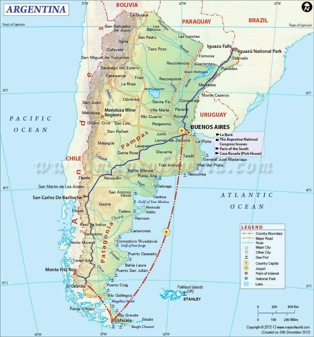
- Argentina
Argentina: a tour of Nature


Some details proper to this trip that I haven't had to deal with before. (a) I've always try to travel light, which is not an easy thing on a nearly month-long trip like this one, with climates varying from humid subtropical to subpolar oceanic. My usual motto of one shirt, one short and one underwear
no longer works. (b) With the new camera (that also takes videos) that I have since last year, a new dilemma presents itself: when to take pictures vs videos. Photography freezes the moment, whereas videography put forth the movements, two things that are a priori contradictory. The solution to (a)... I'd rather keep it to myself. As to (b), I did have some mishaps, but you can make your own opinion by looking at the pictures and the video.
Buenos Aires

La Ciudad Autónoma de Buenos Aires (Autonomous City of Buenos Aires) is the capital and the largest city of Argentina. It is also the second largest metropolitan area in South America, behind the Greater São Paulo in Brazil. The Argentines often call the city Capital Federal to distinguish from the Province of the same name, and the inhabitants of the city Porteños (literally inhabitants of the Port). Note that the city is autonomous - it doesn't belong to the Province of Buenos Aires - just like Washington DC in the United States. Whereas DC has its White House, BA has its Casa Rosada (Pink House) which is the house of the executive and the office of the President of Argentina.
Some describe Buenos Aires as a mix of Paris' architecture, Rome's traffic and Madrid's late-night life. Coming from Europe, I didn't find BA's architecture particularly interesting. An exception is the Cementerio de la Recoleta, which is to BA what Père Lachaise is to Paris. To me, what makes BA interesting is its Ferias, its immense parks and the late-night life.
I stayed in the centre, in the Microcentro area, strategically situated at walking distance to many points of interest: Plaza de Mayo, Plaza del Congresso, the Obelisco, the pedestrian street Florida, la Feria de San Telmo, Puerto Madero, etc. One can get to any part of BA by subway - called Subte - or by city bus. The bus network being much more extensive, the difficulty is to know which bus to take as there are probably more than 150 lines. The waiting queue at the bus stop can be long at rush hours, so that only people at the front of the line can get on before the bus is full. Fortunately the buses are frequent and the next one is never too long behind.

Ah the tango! The dance originated at the end of the 19th century in lower-class districts of Buenos Aires and Montevideo in Uruguay. Consequently, one is almost obligated to go to a tango show while visiting BA. Unfortunately, with the heat wave that occurred in BA and my long walks during the day, I was always too tired at the end of the day to feel like attending a tango show. The only tango I saw are street shows.
In my opinion, BA can be visited in three days, four if one wants to spend a lot of time in the museums. I stayed there four and a half day and found it a little long.
San Antonio de Areco
Located about 115 km (70 mi) northwest of Buenos Aires, San Antonio de Areco is one of the most beautiful town of Buenos Aires Province. It is home to the Fiesta de la Tradición, a week-long event that takes place in early to mid-November where gauchos from all over the Pampas gather. I came there on a mid-week day and was surprised to see no activities. In fact, the main event with the gauchos takes place on the last day of the Fiesta, which is on Sunday.
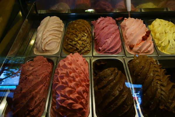
The town is indeed charming, but it can be visited in just a couple of hours, and that includes a visit to the gauchos museum. The highlights of my visit there was when I saw several gauchos wandering on their horses, and when I had an ice-cream in the shade of the trees at a public park to get a relief from the heat. I must say that Argentine ice-cream, helado, is very good (comparable to Italian ice-cream, gelato).
Ushuaia

When I was young, I often watched and liked a television programme on adventures called Ushuaia. I always thought that if I go to Argentina, I would check out Ushuaia.
Ushuaia is the southernmost town in the world and the base for exploring the Antarctic. The view from the airplane when approaching town is quite impressive, with ranges of whitecap mountains that one can almost touch by reaching out the window. The town itself is quite strange. It is not rustic as one may expect from such a remote town. It is not really charming either. Its architecture, if there's one, is not homogenous. Strange is the best adjective I can find to describe the town. That being said, no one comes to Ushuaia for the beauty of the city. People come there to find a job. People come there for the bragging right of being to the southernmost city of the world. People come there to take a cruise to Antarctica. People come there for the wildlife and for the trekking. Note that the guided tour of Estancia Haberton is interesting and informative, especially the visit to its Acatushún museum.
I was told that the weather in Ushuaia is unpredictable and that the rain is part of its charm
. I got there in the afternoon and for the remaining of the day, I saw alternation of rain, snow, hail and sunshine every 10-15 minutes. The next day, it rained all day long. The skies were dreary, the mountains went hiding under the clouds. On the third day, I woke up to a white blanket of snow covering the landscape. It snowed most of the day. The fourth day came with the sun, it was warm like in the spring. With the sun, everything was transformed, everything became more scenic.
With all the rain and snow, even when summer is around the corner, you may ask why the region is named Tierra del Fuego (Land of Fire). When the Europeans first arrived in 1520, with Portuguese explorer Ferdinand Magellan at their head, they saw from the ocean the many fires from the activities of the native population, the Yaghans. That's how the name was given to the archipelago by Magellan.
I stayed 4 days and 4 nights in Ushuaia. If I had planned my trip in advance, I would have traded some time spent in BA and Ushuaia for some time trekking in Torres del Paine National Park in Chile. That said, staying that long in Ushuaia allowed me to see the sun on the last day; the town is prettier under the sunlight and trekking in Tierra del Fuego National Park was also more pleasant.
Patagonia
Patagonia is the region at the southern end of South America, including Tierra del Fuego, even though most people think about the southern Andes when talking about Patagonia. It has one of the lowest density of population on the planet with only 3.8 (or 1.9 depending on the source) inhabitants per km2.
El Calafate/Glaciar Perito Moreno

The flight to El Calafate offers a breathtaking view of large emerald lakes, whitecap mountains and glaciers just before landing. With the view from the airplane, one can appreciate the enormous size of Perito Moreno Glacier. (I was told that I was lucky because not all flights pass above the glacier). Of all the places I visited on this trip, Perito Moreno Glacier is the one that impresses me the most. It is the biggest glacier I've seen to date: 30 km (19 mi) in length, a terminus of 5 km (3 mi) wide, with an average of 74 m (240 ft) above water and 170 m (558 ft) total height.
Perito Moreno Glacier is one of the few glaciers in the world that still advances (as opposed to shrinking). It advances about two metres (6 ft) per day, or 700 m (765 yd) a year. For comparison, Fox Glacier in New Zealand advances in average one metre (3 ft) per week. The advance of the ice blocks produces a constant thunder and cracking kind of sound, and that is what left the biggest impression on me.
El Calafate is the closest town to Perito Moreno Glacier (78 km, 48 mi away) and the main hub for visiting different parts of Los Glaciares National Park and for crossing to Torres del Paine National Park in Chile.
El Chaltén
El Chaltén is a small village in Los Glaciares National Park and the base for climbing Cerro Fitz Roy and Cerro Torre. The streets of the town are empty during the day when people are out trekking, climbing or horse riding somewhere on the mountains. Late afternoon, people start trickling back to town, one by one. Some call El Chaltén the trekking capital of South America.

Cerro Fitz Roy, also called Cerro Chaltén, is probably one of the most photographed mountains in the world. According to some, Chaltén means smoking mountain in Tehuelche, referring to the clouds that often enshroud its summit. Even though it is only 3405 m (11171 ft) high, Mount Fitz Roy is one of the most technically difficult mountains to climb. It was conquered for the first time in 1952 by two French climbers, Lionel Terray and Guido Magnone, one year only before the first successful ascend of Mount Everest.
I hiked the three classical trails in El Chaltén: Laguna de los Tres trail for a close-up view of Cerro Fitz Roy, Laguna Torre trail for a close-up view of Cerro Torre and Loma del Pliegue Tumbado trail that leads to a magnificent panorama of Cerro Fitz Roy and Cerro Torre. For Laguna de los Tres trail, instead of doing the round-trip from El Chaltén, I made the loop by starting at El Pilar. Unfortunately, Mount Fitz Roy was covered by the clouds all day long. It was cold at Laguna de los Tres that day, and with the gusty and strong wind (though according to locals, it was only a breeze in Patagonia) I didn't feel like staying long for exploring the surrounding of the lake. I only made it to around the corner for a view of Laguna Sucia from a cliff.
The next two days, the weather was nice, sunny with calm wind and no cloud - a rarity in Patagonia. With the sunny weather, I was able to stay for a long time at Laguna Torre and Pliegue Tumbado in order to enjoy the landscape. If Laguna de los Tres and Laguna Torre offer respectively close-up views of Cerro Fitz Roy and Cerro Torre, Pliegue Tumbado offers a superb panorama of both of them from the height of the hill. And if I feel very tiny next to Cerro Fitz Roy and Cerro Torre, the panorama from Pliegue Tumbado gives me the impression that the landscape is just part of a miniature model that I can take away with me. It's strange.
After the cold in Ushuaia, and now the wind and the sun on the mountains, my lips are badly cracked. Open the mouth to eat hurts. Oh the joy of trekking in Pat-agony-a. But who would have guessed that just laying on top of a boulder on a cliff or just sitting on a hill, doing nothing but watching the landscape and feeling the warmth of the sunlight, could be that enjoyable.
RN40

No, it's not a chemical formula but a marketing formula for tourism. The Ruta Nacional 40, just like Route 66 in the United States, is a symbol and emblem of Argentina. It is a major north-south road of more than 5100 km (3170 mi), traversing the country from La Quiaca at the bolivian border in the North to Cape Virgenes in the extreme south of Patagonia. A good portion of the RN40 in Patagonia is still unpaved. Points of interest along RN40 between El Chaltén and Esquel are few and far between. Those may be the reasons why few travels on RN40 in Patagonia. That said, I did see some cars, a few bikers and a very brave cyclist.
Chaltén Travel is the only bus company that offers public transportation on the RN40 between El Calafate and San Carlos de Bariloche. This service takes place in the summer only, starting from the 15 of November, with a departure every other day. Since I was in El Chaltén around the 15 of November, I decided to go to Bariloche by bus on Ruta 40. It's a two days bus trip, with an overnight stop in Perito Moreno (the town, to not be confused with the glacier of the same name). If you can, avoid staying at Hotel Belgrano in Perito Moreno because it's dilapidated and too expensive for what it offers. I don't understand why Chaltén Travel partners with that hotel.
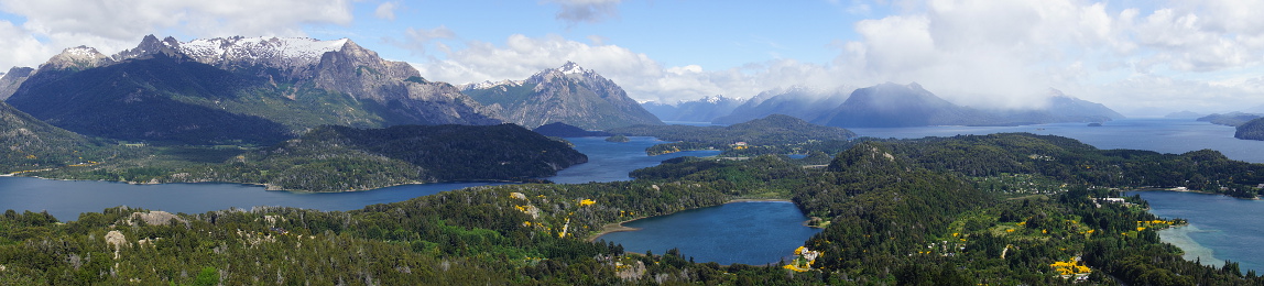
San Carlos de Bariloche

Situated on the southern shores of Lake Nahuel Huapi and surrounded by the national park of the same name, San Carlos de Bariloche is the primary destination of the Lakes District. The region of Bariloche is described by Argentines as the Switzerland of Argentina
, and is known for its landscapes of lakes and mountains, its many chocolate shops, its streams rich in trouts and salmons, and its ski centre which is one of the oldest and largest in South America.
One way to see the landscapes of Nahuel Huapi National Park is to take the Circuito Chico, a scenic loop of 60 km (37 mi). I did the most scenic portion of the loop on bike (~25 km, ~16 mi). One can take the city bus from Bariloche to kilometre 18.3 where the bike rental shop is located. At kilometre 18, one can take the chairlift to the top of Cerro Campanario for a superb panorama.
Another way to see the landscapes is to hire a car and make a drive on the Ruta de los Siete Lagos (Route of the Seven Lakes), which according to guidebooks, is spectacular. It's true that one can see crystal clear lakes and nice landscapes along the road. But to be honest, I found that the landscapes on the Ruta de los Siete Lagos are not as impressive as the landscapes along route 237 going to Buenos Aires, or at least in the first two hours on that road.
Iguazú
Since El Chaltén, my plans for the end of the trip changed frequently. A lot of people have recommended me to go to Iguazú, and once I got to Bariloche, I thought that Iguazú was indeed a good idea. Unable to find a flight to Iguazú (all flights out of Bariloche in the timeline that I wanted was booked), I had to take the bus: 20 hours to get to Buenos Aires, I planned 2 hours to change bus at the bus terminal, then another 20 hours to get to Iguazú. As a result, I had to shorten my stay in Bariloche by two nights.

The first bus was more than two hours late getting to BA, my connecting bus had already left the bus terminal, but they communicated somehow so that the other bus would wait for me on the side of the road. When my bus crossed the other one, I got off, crossed the road and got on the other bus and was on my way to Iguazú. After two nights and 40 hours straight on the busses, I arrived to Puerto Iguazú in the morning, under a torrential rain. Being more tired than I had expected (who would have thought that spending 40 hours not doing anything but sleeping, eating and watching movies could be that tiring), I decided to rest that day and to stay one more night in Iguazú; my last plan change on this trip.
With the heavy rain the previous two days, water levels were higher which made the waterfalls more impressive. The highlight was, with no doubts, the Garganta del Diablo (Devil's Throat). The amount of water going down is massive, the generated sound adds to the feel of the water power, the mist is blinding. Yet, you see little birds flying in and out of the water curtains as if all of that power was nothing. It was so impressive that I decided to come back to the Argentine side the next day, instead of going to the Brazilian side of the waterfalls. With the sunny weather the day before, I noticed that water levels have gone down some, making the waterfalls relatively less impressive. Once more, I spent more than an hour there just to experience the spectacle offers by Garganta del Diablo.
To maximize your experience, try to go there during seasons of high water, on a sunny day (for the rainbows). Take the Paseo Superior first for an overview of the waterfalls, then the Paseo Inferior to watch them from much closer and to better feel their power. Once down to the water level of Río Iguazú, take the boat to Isla San Martín (free) in order to see from close-up the power of Salto San Martín. And finally to top it all, head to Garganta del Diablo last. Discovering the waterfalls at Garganta del Diablo is like discovering the Treasury at the end of the Siq in Petra. On the couple of kilometres long walkway leading there, there is no hint that such a magnificent spectacle is awaiting at its end.
The people
In general, I found that Argentines are friendly, discipline and not aggressive. They are proud of their country, even though they acknowledge there are things that don't go well, such as high inflation, the economic situation, the political class that they consider rather incompetent. Of course, I got this impression from Argentines who speak English or French, thus intellectuals.

I haven't had to get by in Spanish on my own since my trip to Mexico in 1994, this is to say that my Spanish is now very bad (just good enough to make myself understood, but not good enough to understand when people answer me). Had I have a conversational level in Spanish, I could have met more people and made more interesting conversations. Nevertheless, I did meet some interesting Argentines on this trip.
Among things not to do in Argentina is talking about the Falkland Islands (or Malvinas for the Argentines). One evening, at the B&B I stayed in Ushuaia, an Englishman, an Argentine judge and me talked about the forbidden subject, but no fight ensued. The judge said most Argentines don't hold a grudge against the British as they hold the Argentines Generals responsible for wanting to start that war. The English guy said that most British don't really care if the islands went to Argentina as those islands are too far away from the UK for them to relate and they cost an arm and a leg to tax payers.
I thought that my itinerary in Argentina was personal and unique. I quickly realised that thousand of people do more or less the same itinerary. I see again and again the same people in one town then later in another, or in different national parks. It was nice and fun to do some of the segments with some of those world travellers and spending evenings with them.
Practical details
Dates of the trip: 1-28 November 2012
I use the ATMs often on my trips to take money. That allows me not to have to carry too much cash, and also, that usually yields to better exchange rates than in the bureau de change. But that strategy doesn't work well in Argentina because Argentine banks charge a fee for using their ATMs (about 2%). Moreover, they limit the maximum amount that one can withdraw each time to 1000 pesos. Since most of the shops and restaurants don't take credit cards, the cash is quickly spent and thus ATM fees accumulate fast.
There is a penury of coins in Buenos Aires. Often times, stores don't have enough coins, so that they round the total purchase amount to the closest pesos; some time the customer comes ahead, some times the store comes ahead. The ATMs dispense money in AR$ 100 bills only, but most of the stores don't accept a 100 bill for a purchase of less than AR$ 40-50. As aforementioned, credit cards are not widely used in Argentina, even in hotels. Some establishments give you a discount when you pay in cash instead of credit card.
There's something I find interesting in El Chaltén. On one hand, most establishments (hotels, hostels, restaurants, etc.) offer free wifi. But on the other hand, practically none of them accept credit cards. There is now an ATM at the bus terminal. Because El Chaltén is very remote, access to the Internet is done via satellite. On normal conditions, the connection is quite slow, but when the wind blows (and of course that happens often in Patagonia) the connection slows to a crawl, 28k type of crawl (for those of you who still remember the prehistoric modem era).
One pays when boarding the city bus, which only accepts coins (no bills) or the magnetic card. In Buenos Aires, the magnetic card, called Sube, also works in the subway, called Subte, and certain city buses (the older ones) are not equipped to read the Sube card. You buy the magnetic card - AR$ 15 in BA and AR$ 14 in Bariloche - and load it with the amount of money that you want. The appropriate fare is deducted from the card each time you take the subway or the bus. You reload the card when necessary. The incentive is that each trip costs less when using the magnetic card. For instance a normal city bus ticket to go from the bus terminal to the centre of Bariloche costs AR$ 7, but only costs about AR$ 2.5 using the card. When boarding the city bus, tell the driver the stop you're getting off at and he will set the fare to deduct from your card.
They ask (at least to the tourists) for your passport number so often that I now know by heart my number. Your passport number is needed when staying at the hotels, when buying airline tickets, when buying bus tickets, when buying the aforementioned magnetic card, when buying tickets to national parks.
The train network is ... um, forget about it. The bus network is excellent. You can practically go anywhere in Argentina by bus. Sleeper buses are very comfortable and the service is just like on airplanes business class. On those 20-hour bus rides I took (departure late afternoon or early evening, arrival the next day), they serve dinner with wine, breakfast and a snack. The seats are wide and recline almost flat like a bed. Hence, if you have a ride of 8 hours or more, it's worth to do it overnight, on a sleeper bus; it costs more, but you save a night at the hotel and keep the daylight for your favourite tourist activities.
Links
- Buenos Aires Subway
- http://www.subte.com.ar/contenido/home.asp
- Buenos Aires City Bus
- http://www.omnilineas.com/argentina/buenos-aires/city-bus/
- Trails map of El Chaltén
- http://www.horizo.com/argentine/photos/carte_el_chalten2.jpg
- Hostel El Gaucho, Bariloche
- Simple hostel with relax atmosphere, almost familial. The young people working there are friendly and helpful. They did not give me any trouble when I had to reduce my stay from 5 nights to 3 nights. On the contrary, they even help me with finding the buses for Iguazü. Room no 8 on the third floor has a narrow view to Nahuel Huapi Lake.
- Penthouse 1004, Bariloche
- I actually did not stay at this hostel because it had no vacancy during my stay in Bariloche. It was highly recommended to me by other travelers and it has a superb view on lake Nahuel Huapi.
- Nothofagus B&B, El Chaltén
- Spacious rooms, friendly hosts, hearty breakfast and as a bonus, the B&B is green. No kitchen available. English and French are spoken.
- Las Cabañitas, El Calafate
- Small wood cabins, cute but with limited spaces. The owner, Gerardo, has a Business Management diploma from Buenos Aires, but prefers the quiet life in El Calafate, making a living in an area that allows him to exercise his cooking talent. His dishes look delicious (though I didn't try them) with impeccable presentation. English and French are spoken.
Copyright © 2013, Northwest Summit. All rights reserved.
No part of this page may be reproduced, republished or copied without the express written permission of its author.